We had 3 days of exploring a wilderness we had only read about, and looked at on Google Maps. The truth, crazy as it sounds, was that my husband really wanted to see on the ground what looked so intriguing from space. He has become an expert at crafting a trip based on satellite maps -- all without a GPS. A family joke is that GPS stands for George Positioning System.
We took so many pictures and found so many interesting trails that I could never cover them all in one post. This post will cover only part of one hike. I think this is the Chikanishing trail. And that, of course, is now the mare's name.
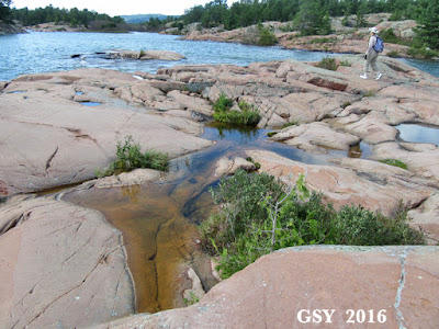
We came out of the forest onto a promontory of red rock, overlooking Georgian Bay, which is the northeastern part of Lake Huron. This was in the Killarney Provincial Park.
The weather was perfect.
Very few boats were to be seen, and there weren't that many people. We wandered at will upon the fantastically eroded and worn Canadian Shield. Ice has ground down these rocks until they look like a mass of raw dough, or maybe paste icing. The smoothed-off surface is endlessly surprising in its textures and variations. We found a place where a low 'pass' was just under the water.
You can see it in the center of the picure below:
As I stared, entranced, it came to me that not all erosion here was done by ice.
Some was done by water.
This is looking roughly north.
I could have watched the waves surge back and forth across this pass for hours.
Blame it on being raised on the high plains: the sea is endlessly fascinating to me. This isn't even the sea: This is the Great Lakes!
Yes, I really could watch surf for hours!
To the right of the above picture is an island, and on that island were once great trees. In its 19th-C timbering days, boats were used to access the island. An iron bolt was driven into the Shield rock at a point opposite the island, and boats were tied to its ring. (Today the Forest Service won't let you tie up to it.) All I had to do was turn around and put Chikanishing down to have a terrific Scale Issues entry. : )
The catch is it looks so much like a concrete dock. You would swear this was some old business's back dock! But it is the Canadian Shield.
I started moving the horse around. The splashes are natural, that is, from the waves.
The lighting angle isn't the best for a dark horse...
But I was having fun.
Scale issues indeed!
I am hoping to some day post more about this trip.


Fascinating, Sue! I am currently teaching erosion in my Earth Science unit to my 4th/5th grade class. May I use some of your photos? I'd especially like to show the one where it looks like concrete but is, in fact, the result of erosion.
ReplyDeleteHi Lynn, Of course you may (w/ crediting)! What a delightful idea. It really did strike me how some of the rocks appeared to be concrete.
DeleteThank you! Will give you credit when I show them. Mother Nature is amazing, and your pictures offer an unusual glimpse into that.
ReplyDeleteWhat beautiful territory. I like that you take a model along needing a name. By the end of the trip, you have a model that reminds you of your adventure. Brilliant!
ReplyDelete